Ask an older Shewan where Shewa is and you will rarely get a line on a map. You will get a list of places. Menz and Tegulet in the north. Merhabete and Selale above the gorges of the Abbay. Ankober on the lip of the eastern escarpment. Debre Birhan on its cold plain. Entoto, and the city that grew below it. Then the country running south and west towards the Awash and the Gurage hills.
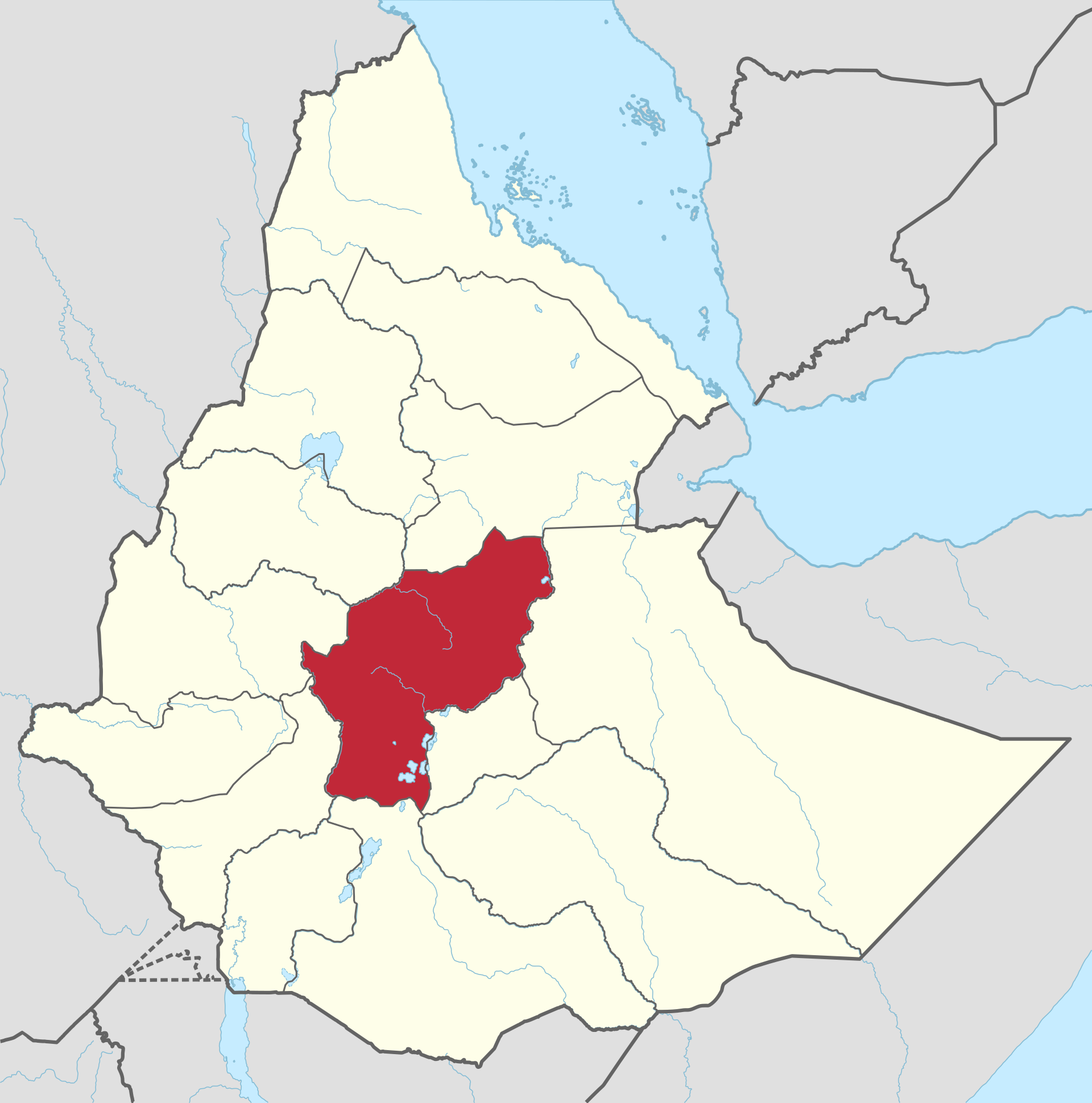
That list is the right place to begin. Shewa was never only a boundary. It was a set of places tied together by churches, markets, roads and a ruling house, and for most of the last seven hundred years those places understood themselves as one country.
High ground and hard edges
The heart of Shewa is high plateau. To the north and west it breaks into the deep gorges of the Abbay (the Blue Nile) and its tributaries. To the east it drops steeply into the Rift Valley and the Awash basin. Many of the places that mattered most sit on those breaks.
Ankober stands at about 2,465 metres on the eastern escarpment. Debre Libanos, the great monastery of Saint Tekle Haymanot, sits on a terrace between a cliff and a gorge that runs down to the Abbay. Debre Birhan, at around 2,840 metres, commands the open plain where the northern routes converge. The traveller and historian David Buxton remarked that the town held “an obvious advantage as commanding what must always have been an important focus of routes.”
This was grain country and sheep country. When the British mission of William Cornwallis Harris lived at Ankober in 1841 and 1842, its naturalists counted 28 varieties of sorghum, 24 of wheat and 16 of barley grown within five miles of the town. Higher up, in Menz, the cold limits the crops, and barley and wool carried the household. Harris noted that the coarse black woollen cloth of Menz, called sekdat, was the material of the king’s own tents.
A Christian country older than its dynasty
Shewa’s Christian history runs deeper than the royal line that later made it famous. The Ethiopian historian Taddesse Tamrat, in Church and State in Ethiopia 1270–1527, describes Christian families settled on the Shewan plateau as subjects of the Zagwe kings in the thirteenth century. He quotes a tradition from Tegulet in which a salt trader says of the Zagwe ruler: “The king of Roha in Angot… he is king over us in this period.”
Taddesse traces an “almost unbroken chain of Christian settlements” along a route running Hayq, Menz, Tegulet, Katata and Silalish. In other words, Menz and Tegulet were already Christian ground before Shewa became the political centre of the kingdom.
Tekle Haymanot, the most beloved saint of the Ethiopian Orthodox Church, came out of this world. Taddesse places his birth about 1215 at Silalish, in Zorare, in what is now the district of Bulga, into a clerical family that tradition says had lived in Shewa for more than ten generations. The monastery he founded, first called Debre Asbo, took the name Debre Libanos in the fifteenth century. The date usually given for its founding is 1284. Its abbot, the Ichege (the head of the Ethiopian monastic order), ranked second in the church only to the Abuna, the metropolitan bishop.
When the kings lived in Shewa
From the late thirteenth century the Solomonic kings increasingly governed from the Shewan plateau. Taddesse follows their camps across Tegulet, Gishe and the edges of Ifat. The chronicle of the wars of Amda Seyon in the 1320s lists his soldiers as coming from “Amhara and Sewä and Gojjam and Dämot,” which is one of the earliest moments where Shewa appears as a recognized source of the kingdom’s strength.
Debre Birhan, whose name means “Mountain of Light,” was founded by Emperor Zara Yaqob after a light was seen in the sky. Richard Pankhurst gives 1456 as the date and suggests the light may have been Halley’s Comet, though the church’s traditional feast day does not match the comet’s brightest days. Zara Yaqob spent twelve of the last fourteen years of his life there.
Later in the fifteenth century the kings kept a fortified town known as Barara. Its exact site is still debated, but Mount Entoto, above present-day Addis Ababa, is one of the candidates. Recent survey work has identified a large walled medieval site of about 30 hectares between the rock church of Washa Mikael and the later church of Entoto Maryam. If the identification holds, the capital Menelik chose in the 1880s was built in the shadow of a capital of four centuries earlier.
That world was badly broken by the wars of the 1520s and 1530s. Barara was sacked in 1529. Debre Libanos was burned in 1531. In the following decades the Oromo migrations reshaped the south, and for much of the seventeenth century Shewa was cut off from the court at Gondar.
The heartland holds, and the kingdom grows again
What survived was the northern core. Menz, in particular, was practically the only part of Shewa not overrun, according to the anthropologist Donald Levine, and it became the base from which the Shewan revival began. In the late seventeenth century a Menz lord, Negasi Krestos, began building a state that his descendants would rule for nearly three centuries.
By the early nineteenth century the Shewan ruler Wossen Seged held a list of districts that reads like a map of the heartland: Moret, Gedem, Marra Biete, Bulga, Mugher, Abichu and Debre Libanos. His son Sahle Selassie, who took the title Negus (king), pushed the frontier further, into Bulga, Karayu, Arsi and Gurage country. Under Menelik, Sahle Selassie’s grandson, the Shewan capital moved south to Entoto and then to Addis Ababa, and Shewa became the centre of the whole Ethiopian state.
The point here is geographic. Shewa’s reach grew from a small, stubborn highland core into a broad province with the national capital at its heart.
Shewa as a province
In the twentieth century Shewa was organized as one of Ethiopia’s provinces. In the 1974 reorganization the provinces were renamed regions (kifle hager). As late as the mid-1980s, Shewa was by a large margin the most populous of them. Statoids, which compiles official Ethiopian administrative data, gives Shewa an area of 85,200 square kilometres in the late Derg period, divided into eleven awrajas (sub-provinces), with an estimated 9,059,917 people in 1988. That figure is for Shewa after Addis Ababa was separated from it as a city-region in 1981.
Look at what that single province contained. The monastery of Debre Libanos and the shrine of Tekle Haymanot. The medieval royal seat of Debre Birhan. The eighteenth- and nineteenth-century capitals of Ankober and Angolalla. Entoto, where Menelik was crowned emperor in 1889. The fields of Menz, the Guassa highlands, the Abbay gorges of Merhabete. The painting town of Fiche in Selale, home of the church painter Alaqa Gebre Selassie Adil (1881–1975), and the Rift Valley towns along the railway to the east. The Gurage highlands to the south-west were Shewan too.
When people in the Shewa Society Association speak of what was lost, this is the country they mean. It was not an ethnic homeland in the modern administrative sense. It was a civilization’s territory, held together by the church calendar, by markets like Aliyu Amba below Ankober, by the roads of the court, and by people who for centuries looked to the same monasteries and the same royal house.
The names that remain
The old name has not disappeared. It survives today on the administrative map in pieces: North Shewa in the Amhara Region, and North, West, East and South West Shewa in Oromia, each named after the former province. Debre Birhan is the capital of North Shewa in the Amhara Region. Fiche is the capital of North Shewa in Oromia.
Those zones carry the name. They do not carry the unity.
For now, it is enough to hold the older map in mind. Draw a line from the barley fields of Menz south through Debre Birhan and Entoto to the Awash, and west from Ankober’s escarpment to the Abbay gorge. That was Shewa. It was a single country, and its people built churches, kept court, wrote and painted, farmed and traded there for seven centuries.
Sources
- Taddesse Tamrat, Church and State in Ethiopia 1270–1527 (Oxford: Clarendon Press, 1972). Full text consulted at Church and State in Ethiopia
- William Cornwallis Harris, The Highlands of Aethiopia, vols. 2 and 3 (London, 1844). vol. 2 and vol. 3
- Bernhard Lindahl, Local History in Ethiopia (Nordic Africa Institute), entries for Ankober and Menz (including summaries of Harris, Levine and Abir). Local History in Ethiopia, Ankober entry and Local History in Ethiopia, Menz entry
- Statoids, “Regions of Ethiopia” (historical administrative data). Regions of Ethiopia
- Donald N. Levine, Wax and Gold: Tradition and Innovation in Ethiopian Culture (University of Chicago Press, 1965). Wax and Gold
- Wikipedia, “Shewa,” “Kingdom of Shewa,” “Debre Libanos,” “Debre Birhan,” “Addis Ababa” (section on Barara and Entoto), “Fiche, Ethiopia,” “North Shewa Zone (Amhara),” “North Shewa Zone (Oromia).” Shewa , Kingdom of Shewa , Debre Libanos , Debre Birhan , Addis Ababa , Fiche,Ethiopia , North Shewa Zone(Amhara) , North Shewa Zone_(Oromia)”>North Shewa Zone (Oromia)
Image: “Shewa in Ethiopia (1943–1987)” by Milenioscuro, via Wikimedia Commons, CC BY-SA 4.0
Before it was split among zones and regions, Shewa was one country of plateaus, monasteries, market towns and royal seats, and its map is the record of a civilization.what-shewa-was